San Antonio will continue to experience significant population growth over the next 25 years. This increase in population will affect many aspects of daily life in San Antonio creating both challenges and opportunities. SA Tomorrow is an unprecedented, multi-faceted planning initiative to accommodate this growth. The planning effort will explore how to preserve the San Antonio culture and increase livability through ensuring housing and transportation choices as our city grows.
The Multimodal Transportation Plan covers the entire City of San Antonio and its extraterritorial jurisdiction. It also takes into account all modes of transportation including: auto, freight, rail, transit, biking and walking. When complete, the plan will:
The Multimodal Transportation Plan serves as a tool that will be used to analyze transportation priorities to best meet overall community goals. The plan also fulfills the transportation component of the San Antonio Comprehensive Plan, implements the goals of SA 2020; complements the Alamo Area MPO’s Mobility 2040: Metropolitan Transportation Plan; and maximizes infrastructure investments.
The following maps illustrate the existing conditions of our transportation system.
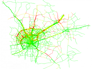
According to the Alamo Area Metropolitan Planning Organization, San Antonio roadways experienced minimal congestion as recently as 2010.
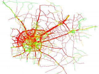
Looking forward to 2040, many of San Antonio's major roadways will be at or over capacity.
©2015 City of San Antonio